Spatial Method provides accurate 3D laser scanning, LiDAR and point cloud capture for architecture, engineering and construction projects across Brisbane. Using industry-leading Trimble X7 technology.
Core Service Offerings
Trimble Technology
Ready Deliverables
Spatial Method is a Brisbane-based 3D laser scanning and BIM consultancy specialising in LiDAR scanning, point cloud surveys, as-built documentation, and scan-to-BIM services. We work with architects, engineers, builders, and developers to capture accurate existing-condition data for residential, commercial, industrial, and heritage projects.
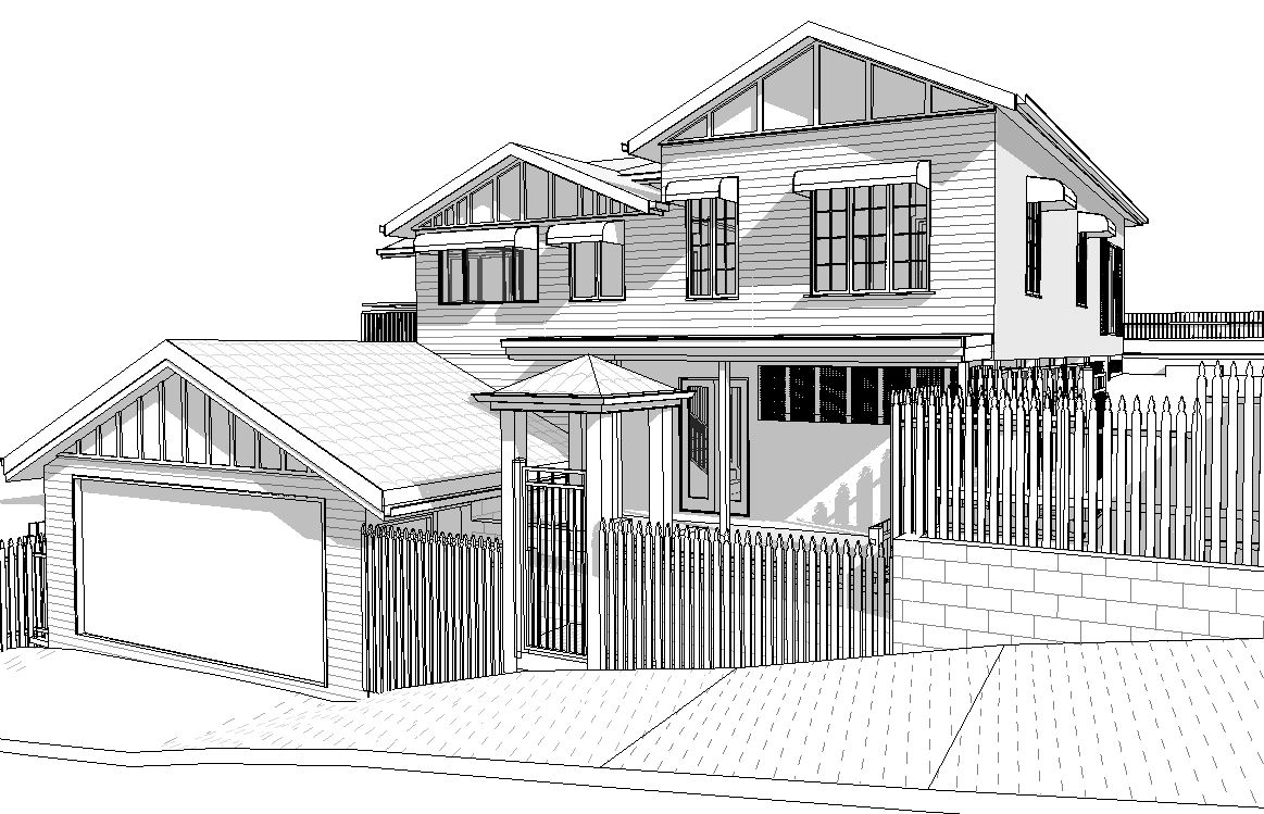
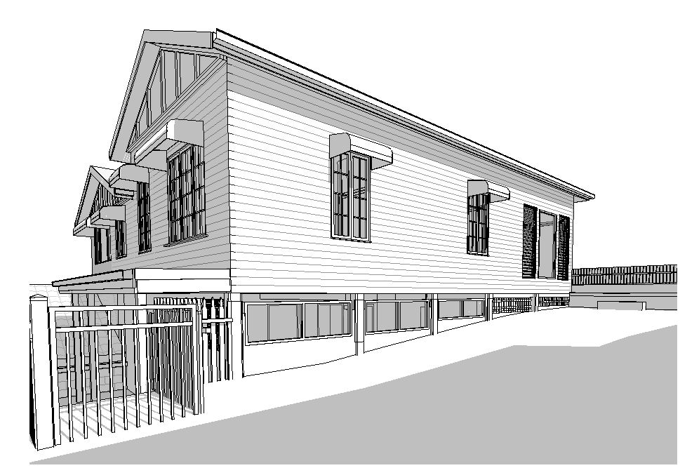
Our deliverables are structured to integrate directly into Revit, AutoCAD, Navisworks, and BIM workflows. From registered point clouds to as-built CAD drawings and BIM models, every file is cleaned, accurate, and ready for immediate use by your design team.
We focus on efficient workflows and modern technology to deliver specialist-level accuracy at pricing suitable for projects of all sizes.
Our scanning methods are quick and minimally disruptive, allowing us to collect comprehensive site data while keeping downtime to a minimum.
We don't just supply raw files. Our deliverables are cleaned, registered, and structured so your design team can begin work straight away.
Accurate existing-condition data helps reduce costly onsite surprises, design clashes, and variations during construction.
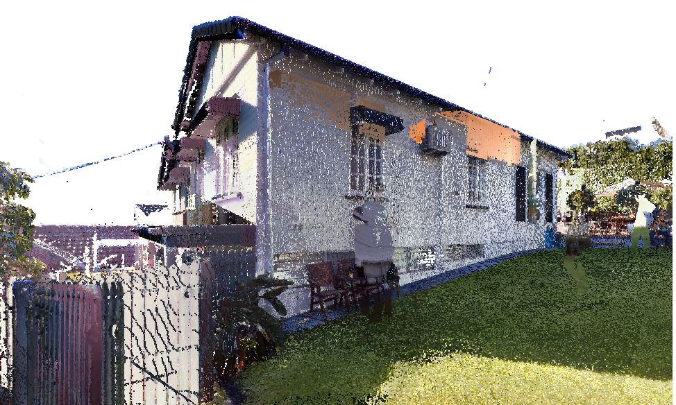
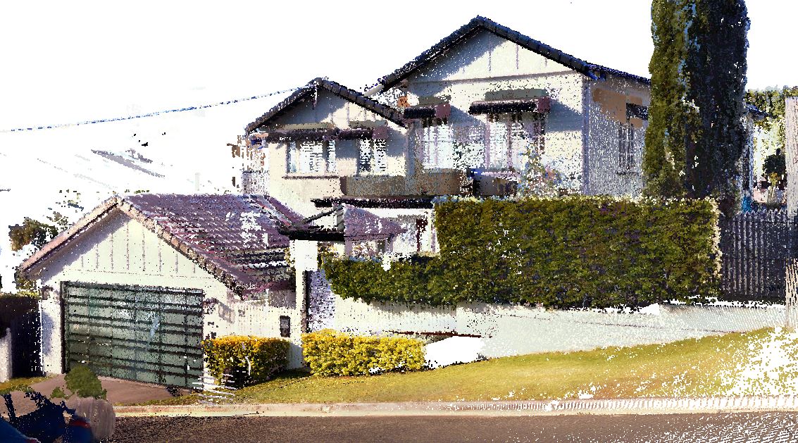
Our LiDAR scanning services use the Trimble X7 survey-grade laser scanner to capture highly accurate 3D data of existing buildings and environments. The technology rapidly records millions of measurements to create precise digital representations suitable for renovations, refurbishments, construction, infrastructure, and heritage projects.
Clients receive cleaned and registered scan data in formats including E57, RCP, and RCS with survey-grade accuracy. Typical turnaround times range from 48 hours to several business days depending on project scope.
LiDAR stands for Light Detection and Ranging, a laser-based technology that measures physical spaces with extreme accuracy. It captures millions of points per second to create detailed 3D representations of existing buildings and environments.
We supply cleaned, colourised, and registered point cloud datasets ready for immediate use. Deliverables can be provided in E57, RCP, RCS, and other industry-standard formats to suit your workflow.
Our LiDAR scanning services are ideal for architects, engineers, builders, developers, and facility managers who require reliable existing-condition information. Accurate scan data supports better planning, coordination, and construction outcomes across all project stages.
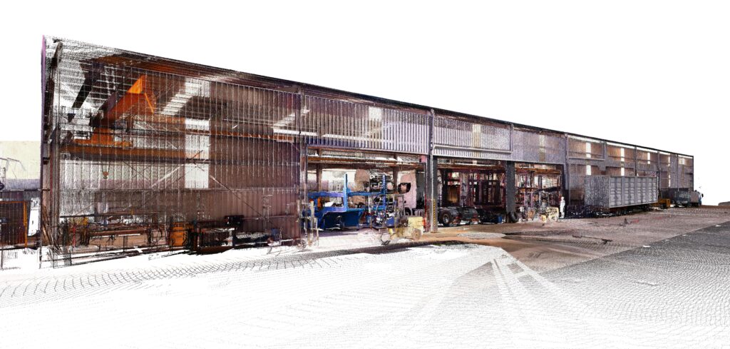
Using the Trimble X7 laser scanner, we capture detailed point cloud surveys for buildings, infrastructure, and complex environments. Point cloud scanning is ideal for renovations, clash detection, BIM workflows, as-built verification, and projects requiring accurate spatial documentation.
Clients receive survey-grade registered point cloud files compatible with major CAD and BIM software platforms. Data is delivered quickly in formats including E57, RCP, LAS, and RCS.
A point cloud survey captures millions of precise 3D coordinates across a physical space or structure. These points combine to form a highly accurate digital representation used for measurement, modelling, and design coordination.
We provide point cloud deliverables in formats including RCP, E57, LAS, and RCS. These file types integrate seamlessly with Revit, AutoCAD, Navisworks, ArchiCAD, and other BIM platforms.
Point cloud data can be imported directly into Revit, AutoCAD, and Navisworks for design development and coordination. This allows project teams to model, verify, and document existing conditions with confidence.
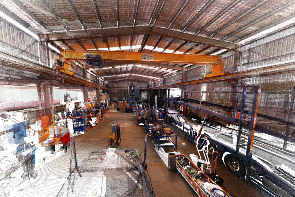
Our 3D laser scanning services use the Trimble X7 to capture accurate building and site data for renovations, refurbishments, heritage recording, and construction verification. The technology records highly detailed spatial information quickly and with minimal disruption onsite.
Deliverables include registered point cloud files, as-built documentation, and BIM-ready datasets supplied in industry-standard formats. Fast turnaround times help keep projects moving without delays.
3D laser scanning uses LiDAR technology to record millions of accurate spatial measurements across buildings and structures. The result is a detailed digital model of existing conditions suitable for planning, design, and verification.
We provide cleaned and registered scan data ready for CAD drafting, BIM modelling, and documentation workflows. Deliverables are available in E57, RCP, RCS, and additional formats as required.
Our building scanning services are well suited to heritage sites, complex structures, and difficult-to-measure environments. Accurate scan data gives architects, engineers, and builders confidence when planning sensitive or high-detail projects.
Contact our team to discuss your project scope, site requirements, and required deliverables. We’ll review the details and provide a clear, fixed-scope quote with no obligation.
Our team attends site with the Trimble X7 scanner and captures accurate spatial data efficiently and safely. Scanning is fast, non-intrusive, and designed to minimise disruption to ongoing operations.
Captured scan data is processed, cleaned, and registered into accurate point cloud datasets. Files are structured for immediate use within your preferred CAD or BIM workflow.
Final deliverables are supplied in your required formats including E57, RCP, RCS, RVT, and DWG. We can also provide modelled Revit and CAD outputs ready for coordination and documentation.
01
We use efficient workflows and modern scanning technology to deliver high-quality spatial data without unnecessary complexity or inflated costs. Our services are suitable for projects of all sizes, from residential renovations through to commercial and industrial developments. Accurate data should be accessible, practical, and ready to support real-world project outcomes.
02
Our scanning process is designed to minimise downtime while still capturing comprehensive site information. We work efficiently within live environments including commercial buildings, healthcare facilities, and active construction sites. Fast site capture means projects can continue operating with minimal interruption.
03
We don’t simply hand over raw scan files. Every dataset is cleaned, registered, and organised to suit real design and documentation workflows. Your team can open the files and begin modelling, drafting, and coordination immediately without additional processing.
04
Accurate existing-condition information reduces the risk of clashes, variations, and costly onsite surprises during construction. Reliable scan data allows project teams to identify issues earlier and coordinate designs with greater confidence. Better data upfront leads to smoother project delivery and fewer unexpected problems onsite.
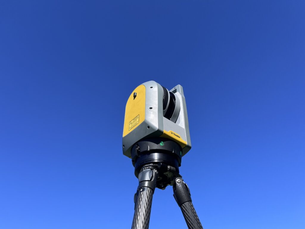
Spatial Method uses the Trimble X7 survey-grade laser scanner to deliver highly accurate and reliable spatial data across every project. The X7 is known for its precision, speed, and automatic registration capabilities, making it one of the leading scanners used within the AEC industry. We invested in this technology to provide clients with dependable scan data that supports efficient design, documentation, and construction workflows.
Tell us your project — we’ll scope it, quote it, and have a team on site this week. Same-day quotes on all projects.